

Overview
The Zenmuse P1 is the new benchmark for aerial surveying, offering extraordinary efficiency and remarkable accuracy. Equipped with a 45 MP full-frame sensor and a global mechanical shutter, it can capture centimeter-accurate data with real-time position and orientation compensation technology. The P1 also includes a 6 months license for DJI Terra Electricity Version, making it the go-to tool for aerial photogrammetry.
With a 3-axis gimbal and Smart Oblique Capture feature, the P1 allows for efficient and versatile data collection. It can cover 3 km2 in a single flight, taking a photo every 0.7 seconds. The TimeSync 2.0 system ensures precise synchronization between the camera, flight controller, RTK module, and gimbal. Additionally, the P1 offers smart data management and a fieldwork report to verify data quality immediately post-flight. It can be used for various applications, including topographic mapping, cadastral surveying, AEC and surveying, natural resource management, geological investigation, and disaster site modeling.
Summary
Weight: 0-2kg
Included in box
1x Gimbal and Camera
1x SD Card (128GB)
1x Storage Case
1x Camera Body Cap
1x Lens Rear Cap
1x Lens Cleaning Cloth
1x Lens Cap
1x DJI DL 35mm Lens
1x DJI Terra Activation Code
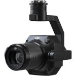
About the DJI Zenmuse P1 (ENT)
The New Benchmark for Aerial Surveying
The Zenmuse P1 integrates a full-frame sensor with interchangeable fixed-focus lenses on a 3-axis stabilized gimbal. Designed for photogrammetry flight missions, it takes efficiency and accuracy to a whole new level.
Your Go-to Tool for Aerial Photogrammetry
Extraordinary Efficiency
The P1 includes a full-frame, low-noise high-sensitivity sensor that can take a photo every 0.7 s during the flight, and covering 3 km2 [2] in a single flight.
Remarkable Accuracy
Equipped with a global mechanical shutter and the all-new TimeSync 2.0 system, which synchronizes time across modules at the microsecond level, the Zenmuse P1 lets users capture centimeter-accurate data combined with the real-time position and orientation compensation technology.
Robust Versatility
Create 2D, 3D, and detailed models thanks to the integrated 3-axis gimbal that can be outfitted with 24/35/50mm lenses and the Smart Oblique Capture feature.
Efficiency to Cover It All
Full-frame Camera
45MP Full-frame Sensor
4.4μm Pixel Size
Low-noise, high sensitivity imaging extends daily operational time
Take a photo every 0.7 s during the flight
TimeSync 2.0 aligns the camera, flight controller, RTK module, and gimbal at the microsecond level
Work Smart, Work Fast
Smart Oblique Capture
Cover 7.5 km2 [4] in a single workday with the P1. Elevate the efficiency of your oblique photography mission using Smart Oblique Capture, where the gimbal automatically rotates to take photos at the different angles needed. Only photos essential to the reconstruction will be taken at the edge of the flight area, increasing the efficiency of post processing by 20%[5] to 50%[6].
Smart Data Management
Your mission data management – streamlined.
Mission result files are automatically associated with the Mission Name and Mission Time.
A centralized storage location for photos, GNSS data, and TimeStamps.MRK files.
The image metadata contains the camera’s intrinsic and extrinsic parameters and the status of RTK.
Fieldwork Report
Verify data quality immediately post-flight by checking the position data and number of the images acquired, as well as RTK status and positioning accuracy.
A Mission Mode for Any Scenario
Effortlessly acquire oblique images from multiple angles that meet 3D modeling requirements across industries such as urban planning and centimeter-level accurate cadastral surveys to serve 3D reality models and smart city planning.
Application Scenarios
Topographic Mapping
Capture data that meet the 1:500 scale accuracy requirements without GCPs.
Cadastral Surveying
Quickly generate centimeter-level accurate 3D reality models.
AEC and Surveying
Manage the full project lifecycle with 2D and 3D drone data.
Natural Resource Management
Measure, classify, or determine the ownership of water bodies and forests.
Geological Investigation
Safely gather millimeter-level accurate aerial data of geological hazard sites.
Disaster Site Modeling
Gain real-time overviews of vast disaster-struck areas to help teams make critical decisions.
General
Product Name ZENMUSE P1
Dimensions 198×166×129 mm
Weight Approx. 800 g
Power 20W
IP Rating IP4X
Supported Aircraft Matrice 300 RTK
Operating Temperature Range -20° to 50° C (-4° to 122° F)
Storage Temperature Range -20° to 60° C (-4° to 140° F)
Absolute Accuracy Horizontal: 3 cm, Vertical: 5 cm *
* Using Mapping Mission at a GSD of 3 cm and flight speed of 15 m/s,
with an 75% front overlap rate and a 55% side overlap rate.
Camera
Sensor Sensor size (Still): 35.9×24 mm (Full frame)
Sensor size (Max video recording area): 34×19 mm
Effective Pixels: 45MP
Pixel size: 4.4 μm
Supported Lenses DJI DL 24mm F2.8 LS ASPH (with lens hood and balancing ring/filter), FOV 84°
DJI DL 35mm F2.8 LS ASPH (with lens hood and balancing ring/filter), FOV 63.5°
DJI DL 50mm F2.8 LS ASPH (with lens hood and balancing ring/filter), FOV 46.8°
Supported SD Cards SD: UHS-I rating or above; Max capacity: 512 GB
Storage Files Photo / GNSS Raw Observation Data/ Image Log File
Photo Size 3:2 (8192×5460)
Operation Modes Photo, Video, Playback
Minimum photo interval 0.7 s
Shutter Speed Mechanical Shutter Speed: 1/2000*-1 s
Electronic Shutter Speed: 1/8000-1 s
*Aperature value no larger than f/5.6
Aperture Range f/2.8-f/16
ISO Range Photo: 100-25600
Video: 100-25600
Video
Video Format MP4,MOV
Video Resolution 16:9 (1920×1080)
16:9 (3840×2160)*
*Only 35mm lens supported
Frame Rate 60fps
Gimbal
Stabilized System 3-axis (tilt, roll, pan)
Angular Vibration Range ±0.01°
Mount Detachable DJI SKYPORT
Mechanical Range Tilt: -130° to +40°;
Roll: -55° to +55°;
Pan: ±320°
Accuracy without GCPs: 3 cm horizontally / 5 cm vertically
Global Mechanical Shutter, Shutter Speed 1/2000 Seconds
Smart Oblique Capture
45 MP Full-frame Sensor
Includes a 6 months license for DJI Terra Electricity Version


Reviews
There are no reviews yet.